Start with the municipal question, not the number of sensors
A municipality rarely has only one air-quality question. It may need to understand whether two neighbourhoods behave differently, investigate a traffic corridor, reconstruct recurring complaints, evaluate a mobility intervention or decide where deeper assessment is justified. Those questions do not necessarily require the same measurement architecture.
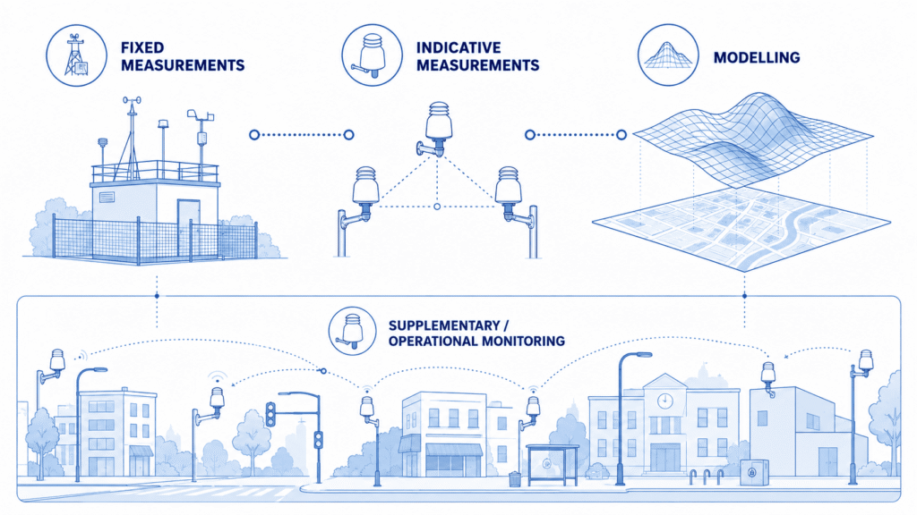
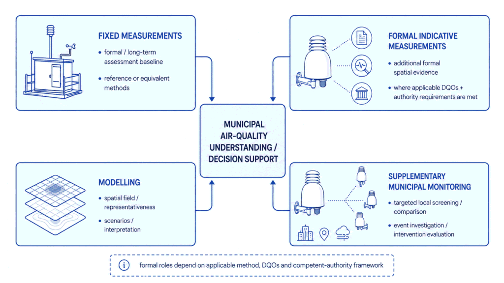
The first design decision is therefore not how many monitoring nodes to buy. It is which questions the programme needs to answer and which evidence layer is appropriate for each one. A useful municipal programme can combine official assessment, formal indicative measurements, modelling and supplementary local monitoring without pretending that those layers have the same role.
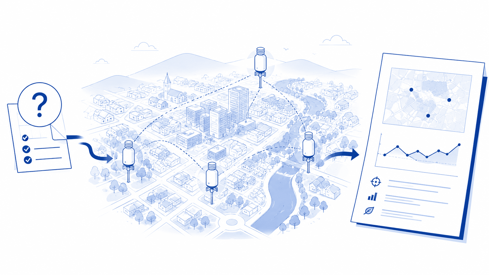
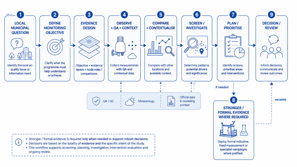
The practical objective is an evidence architecture: define the municipal question first, choose the measurements and comparisons that can answer it, maintain the network well enough for the data to remain interpretable, and introduce stronger or more formal evidence when the consequence of the decision requires it.
Common municipal monitoring objectives include:
- Spatial screening – where do persistent differences appear across the area of interest?
- Hotspot investigation – does a specific local environment behave differently from a meaningful comparison location?
- Event investigation – when and under what conditions do recurring episodes occur?
- Intervention evaluation – does the measured pattern change after a mobility or traffic-management intervention?
- Planning support – which areas deserve closer attention, modelling or stronger measurement?
- Public information – what local evidence can be communicated responsibly, with its status and limitations clear?
Each objective changes the study design: pollutant selection, site selection, monitoring duration, time resolution, comparison strategy, contextual data, interpretation and escalation criteria. A network that begins with a device count and only later asks what the measurements mean has the design sequence backwards.
The EU framework: what a municipality needs to know
Directive (EU) 2024/2881 provides the current EU framework for ambient-air assessment. Fixed measurements remain the formal measurement backbone where required by the Directive, while indicative measurements are a distinct formal category with specific data-quality objectives. Modelling also has defined roles in spatial assessment and representativeness. Municipal supplementary monitoring can complement these approaches by addressing local screening, comparison and investigation needs, provided its evidential role is clearly distinguished from formal assessment.
A municipality may also operate a supplementary local network for screening, comparison, investigation or evaluation. That network can be professionally designed and decision-useful without automatically becoming a formal indicative-measurement network under the Directive. Formal indicative use depends on the pollutant, measurement method, achieved data quality, QA/QC, deployment and the applicable competent-authority framework.
Indicative measurements were already recognised before the 2024 recast; the recast gives complementary spatial evidence a more systematic role. The adopted Commission Implementing Decision (EU) 2026/1208 adds technical implementation detail for modelling and spatial representativeness, but it is not a general certification scheme for sensor networks.
Build the municipal evidence architecture around the question
Once the objective is defined, the municipality can decide which evidence layers should contribute. The useful question is not which layer is universally “best”, but what each layer adds to the specific decision and where another layer is needed.
| ENCE LAYER | WHAT MUNICIPAL QUESTION IT HELPS ANSWER | WHERE IT ADDS VALUE | WHEN ANOTHER LAYER MAY BE NEEDED |
|---|---|---|---|
| Fixed measurements | What does the formal / long-term assessment baseline show? | High-assurance, comparable evidence within the official assessment framework; useful anchor for context and comparison. | When the local question falls outside the spatial or temporal representation of the fixed points, add modelling, indicative or supplementary evidence as appropriate. |
| Formal indicative measurements | Where can additional formal measurement evidence improve spatial understanding or assessment? | Additional spatial observations and complementary assessment when the applicable method, DQOs and authority framework are satisfied. | Use the wider formal assessment architecture when the conclusion requires evidence beyond the scope or quality of the indicative deployment. |
| Modelling | What does the spatial field suggest between measurement locations, or under a scenario? | Spatial interpretation, representativeness, scenario analysis and identification of areas that may need closer measurement. | Use appropriate measurements for model evaluation, local event detail or questions that the model cannot resolve reliably. |
| Supplementary municipal monitoring | What local timing, contrast or event pattern does the municipality need to understand? | Targeted screening, comparison, event reconstruction, intervention evaluation and prioritisation at local scale. | Escalate to formal indicative, fixed-measurement or specialist evidence when a statutory or high-consequence conclusion requires it. |
These layers can be used together. A supplementary corridor network, for example, may be interpreted against official background data and meteorology, with modelling used to understand the broader spatial pattern. The architecture should be designed around the question rather than around a hierarchy in which one method simply replaces another.
Give every monitoring point a role
A distributed network becomes easier to interpret when every location has a defined function in the study design. A node should exist because it answers a question or creates a comparison, not because there was space on a map.
| NODE ROLE | WHY IT IS THERE | KEY DESIGN SAFEGUARD |
|---|---|---|
| Background / context node | Provides a local comparison context against which a target location can be interpreted. | Select a location that represents the comparison needed for the specific study; “background” is not a universal distance rule. |
| Hotspot / source-proximate node | Examines a targeted local environment such as a traffic corridor or other location of concern. | Proximity can show a local pattern but does not by itself prove source attribution. |
| Comparison node | Creates a deliberate contrast with the target location, intervention area or operating condition. | The comparison should be chosen for the hypothesis being tested, not merely because it is convenient. |
| Intervention node | Tracks the location expected to be directly influenced by a planned measure. | It is strongest when paired with a baseline, comparison location and contextual variables. |
| Sensitive-location node | Investigates conditions around a locally relevant receptor such as a school or other sensitive environment where justified. | Its role is local investigation; it does not automatically represent a wider neighbourhood or establish compliance. |
Not every municipal network needs every role, and no universal spacing or minimum node count follows from these labels. The principle is simpler: every monitoring point should have a defined purpose before it is installed.
Design comparisons before adding density
For many municipal questions, comparison design is more valuable than raw sensor density. A single roadside node can show a time series, but a purposeful contrast with another relevant urban environment helps answer whether the corridor behaves differently. A single intervention location can show change over time, but a pre-defined comparison helps separate the intervention signal from weather, seasonality and wider city trends.
The same logic applies to recurring complaints. A local node may capture the timing of an episode; meteorology, activity logs and a relevant comparison location can help determine whether the pattern is spatially local, widespread or coincident with a particular operating condition. That still does not establish legal source attribution, but it produces a stronger basis for deciding what to investigate next.
Comparison locations do not need to be “clean” or remote. They need to create the contrast required by the monitoring objective. This is study-design logic, not a universal siting prescription: the suitable locations, distances and duration depend on pollutant behaviour, urban form, traffic or activity patterns, meteorology and the decision the municipality is trying to support.
From municipal objective to monitoring approach
The table below translates common municipal objectives into a practical combination of evidence sources, network-design choices and escalation criteria. The focus is on how to structure the monitoring programme around the decision the municipality needs to support.
| MUNICIPAL OBJECTIVE | USEFUL EVIDENCE MIX | NETWORK / STUDY-DESIGN IMPLICATION | WHEN TO ESCALATE |
|---|---|---|---|
| Understand differences between neighbourhoods | Supplementary distributed monitoring + official / background evidence + modelling where useful. | Choose comparison locations representing different urban conditions; preserve consistent operation long enough to distinguish recurring contrasts from short-term noise. | If a high-consequence or statutory claim is required, introduce formal assessment evidence appropriate to that claim. |
| Investigate a traffic corridor | Targeted local nodes + traffic data + meteorology + official / background context. | Use a source-proximate or corridor location plus at least one meaningful comparison; define the pollutant and time scale around the traffic question. | Commission specialist or formal measurement when legal, compliance or source-attribution conclusions are required. |
| Investigate recurring complaints / events | Continuous local measurements + meteorology + operational / complaint logs + relevant comparison. | Place locations to reconstruct timing and spatial behaviour; ensure clocks, metadata and contextual records can be aligned. | Escalate to source-specific or formal investigation when the pattern warrants it. |
| Evaluate a traffic or urban intervention | Supplementary measurements + before / after design + comparison location + meteorological context. | Collect a pre-intervention baseline; preserve comparable monitoring after implementation; define the expected time scale of response in advance. | Use modelling or stronger measurement if attribution or formal effectiveness claims are required. |
| Prioritise areas for further assessment | Supplementary screening + modelling / official context. | Distribute points to reveal contrasts or recurring patterns, not simply to create even geographic density. | Deploy formal indicative, fixed-measurement or specialist campaigns at prioritised locations when required. |
| Support city-wide policy / planning | Official assessment + modelling + selected supplementary evidence. | Use the local network to add targeted spatial / temporal context around specific planning questions rather than as the sole city-wide evidence layer. | Engage the competent-authority / formal assessment framework where the decision depends on statutory ambient-air assessment. |
| Public information | Quality-managed local measurements + official / contextual evidence + clear evidence-role labelling. | Publish methodology, time basis, data status and limitations; distinguish local measurements from official assessment and modelling outputs. | Do not replace statutory public-information or alerting obligations with a supplementary dashboard. |
From local measurements to municipal decisions
A local monitoring programme is useful when it changes the quality of the next decision. Fit-for-purpose measurements can support screening, investigation, prioritisation, planning and evaluation without automatically determining legal compliance or replacing the competent authority’s statutory assessment.
OBSERVE -> SCREEN -> INVESTIGATE -> PLAN / PRIORITISE -> STRONGER EVIDENCE WHERE REQUIRED
The ladder connects the whole programme: define the objective, build the evidence architecture, assign node roles and comparisons, observe with QA and context, then decide what the pattern justifies. “Stronger evidence” is conditional, not automatic. A municipality can use supplementary evidence to choose where to inspect, what to model, which area to prioritise or how to redesign a study. Formal escalation is needed when the consequence of the conclusion demands a different evidential standard.
Three common municipal monitoring scenarios
Scenario 1 – Traffic corridor
Question: is one corridor systematically different from comparable urban locations? A useful design combines a targeted corridor node with a purposeful comparison location, meteorology and traffic context. The goal is not to prove from one concentration trace that traffic caused every observed peak. It is to establish whether a repeatable local contrast exists, when it is strongest and whether the pattern justifies deeper analysis. The network can therefore support screening, investigation and prioritisation. If the municipality later needs a legal or source-specific conclusion, it can introduce the appropriate specialist or formal evidence rather than asking the original screening network to carry a role it was not designed for.
Scenario 2 – Intervention evaluation
Question: did measured conditions change after a mobility or traffic-management intervention? Start before implementation, not after it. A useful programme captures a baseline at the target location, retains a comparison location and records meteorological or other contextual conditions that could influence the result. After implementation, use the same design to compare patterns over an appropriate period. A before / after difference is evidence of change, not automatic proof of causality. If the policy claim requires attribution, scenario modelling, a stronger quasi-experimental design or higher-assurance measurements may be needed.
Scenario 3 – Recurring local complaints
Question: when and under what conditions does the reported episode occur? Continuous local measurement is valuable because it can be aligned with complaint timestamps, wind conditions, operational logs and a relevant comparison location. The municipality can use that evidence to reconstruct events, determine whether a pattern recurs and target inspection or further monitoring. The supplementary network does not by itself identify the responsible source or establish legal responsibility. Where the evidence points to a specific issue, the next step may be a source-specific investigation, specialist sampling or another formal method appropriate to the consequence of the finding.
A monitoring network is an operational system, not a hardware purchase
A professional municipal network is not “number of nodes x purchase price”. A professional municipal monitoring programme should treat sensor selection, field-study design, performance assessment, calibration, QA/QC, network operation, data management and communication as connected parts of the same measurement lifecycle.
For a municipality, that lifecycle can be organised into four layers:
- Objective and field design – define the decision, select pollutants and locations, secure permissions, install equipment and provide reliable power and connectivity.
- Measurement quality and fleet operation – verify performance, define calibration or comparison strategy, apply QA/QC, supervise uptime, maintain equipment and manage sensor replacement.
- Data infrastructure and traceability – transmit and store measurements, preserve metadata, flag data status, keep processing consistent across the fleet and maintain traceability between raw observations and adjusted datasets where applicable.
- Interpretation and communication – analyse measurements with meteorology and other context, prepare dashboards or reports, communicate evidence appropriately and review whether locations and objectives still remain valid.
Study design, verification, quality control and intended data use should therefore be defined before deployment rather than treated as downstream tasks.
A low hardware price does not automatically create a low-cost monitoring programme. Total cost of ownership includes the labour, quality processes, servicing, data infrastructure and interpretation required to keep the evidence useful. The programme creates value only if the full measurement lifecycle produces information that remains interpretable and traceable over time.
Distributed does not mean “as many nodes as possible”
Distributed monitoring is useful because local questions often require more than one purposeful observation. But density is not the objective; information coverage is. Node count should follow the number of distinct environments, comparisons and monitoring questions the programme needs to resolve – not city size alone.
Adding a node creates value only when its role is defined, its data quality can be maintained, the resulting comparison remains interpretable and the information can influence a real decision. A smaller network with purposeful contrasts can be more useful than a larger network of interchangeable locations. Conversely, some questions genuinely require broader coverage. The point is to justify density from the evidence design, not treat density as the objective in itself.
Make the evidence role visible when communicating data
Municipal dashboards and reports should make the evidence role visible. Where several layers are presented together, readers should be able to distinguish official statutory assessment data, formal indicative measurements, supplementary municipal measurements and modelling outputs. The labels should reflect the actual status of the data, not the marketing description of the device.
Useful communication also states the time basis, data status, relevant QA or processing information and material limitations. A local dashboard can be valuable for transparency and investigation without implying that every displayed value is a statutory assessment result. Keeping those roles clear protects both the usefulness of the local network and the integrity of the official assessment framework.
Where Aernode fits in a professional municipal monitoring programme
Within the Urban Areas & Traffic context, Aernode is relevant as a system supporting the municipal monitoring lifecycle rather than as a collection of stand-alone sensor boxes. The Aernode Air Quality Monitor provides configurable outdoor field nodes that can be assigned purposeful roles in distributed deployments.
At network level, Aernode Cloud supports fleet supervision, project configuration, structured data storage, calibration management and secure data access. Reporting Tools provide real-time and historical views, analytics, reports and public-facing outputs that can support investigation, review and stakeholder communication.
That architecture fits a municipal programme in which field nodes have defined measurement roles, the network is supervised and maintained as a fleet, data remain structured and traceable, and interpretation and reporting occur in a managed workflow. Aernode can support supplementary municipal monitoring and may support projects targeting formal indicative use where the applicable pollutant, measurement method, achieved data quality, QA/QC, deployment and competent-authority framework actually support that role. The product label alone does not establish formal indicative status.
Use each evidence layer for the decision it can support
A municipal air-quality programme is strongest when it begins with the decision rather than the device. Define the question, identify the evidence mix, assign every location a role and create the comparisons needed to interpret the result. Then operate the network well enough that measurements remain traceable, comparable and useful over time.
Fixed measurements, formal indicative measurements, modelling and supplementary monitoring can all contribute, but they do not need to answer the same question. Supplementary measurements can be highly useful for local screening, investigation and evaluation without silently becoming statutory assessment data. Formal evidence can be introduced when the consequence of the conclusion requires it.
The practical design principle is therefore simple: build for information coverage, not sensor count; use comparison before density; and make the evidential role of each layer explicit from measurement through to municipal action.
Technical References
- Directive (EU) 2024/2881 of the European Parliament and of the Council on ambient air quality and cleaner air for Europe (recast).
- Commission Implementing Decision (EU) 2026/1208 laying down rules for modelling applications and determining the spatial representativeness of sampling points.
- European Commission Joint Research Centre, JRC130050 – Guidance on low-cost sensors deployment for air quality monitoring experts based on the AirSensEUR experience.
- European Commission Joint Research Centre, JRC130628 – Guidance on low-cost air quality sensor deployment for non-experts based on the AirSensEUR experience.