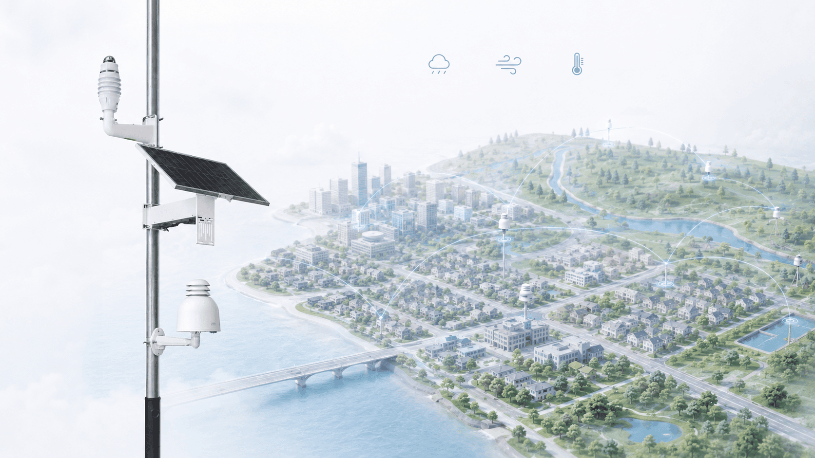
Municipalities often rely on regional weather stations and forecasts, but these sources cannot always describe individual neighbourhoods, drainage areas, parks or exposed infrastructure sites. Air temperature, rainfall and wind can vary significantly where built form, vegetation and terrain change over short distances.
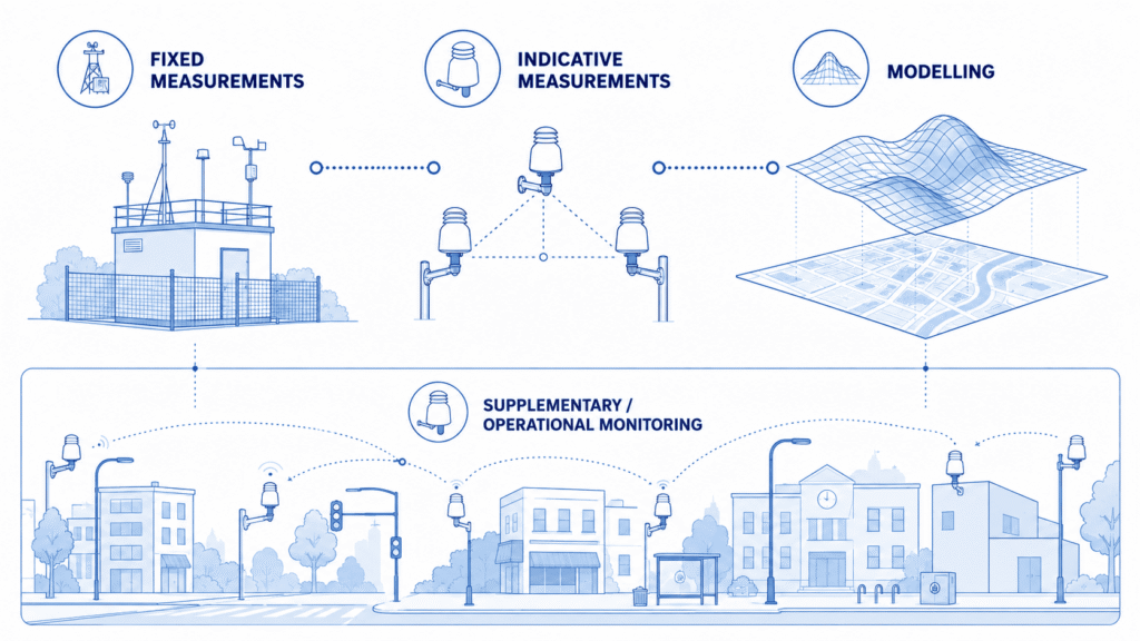
A local weather monitoring network can add this operational detail when its sites and measurements are chosen around specific municipal questions. It should complement – not attempt to reproduce – national or regional meteorological services, official warning systems or formal climatological observing networks. Urban observing requirements are city-specific, so local observations are most useful when they fill a defined spatial or operational gap.
In this Guide, municipal weather monitoring means local operational observation of parameters such as air temperature, relative humidity, rainfall and wind, with pressure, solar radiation or other environmental data added where the use case requires them.
Start with municipal decisions, not station count
The first design question is not how many stations to buy, but what municipal decisions or uncertainties need better local evidence. Station count is an outcome of the monitoring objectives, site diversity and available infrastructure; it should not be the starting specification.
The same measurement can support different purposes depending on its location and operational use.
| Municipal question | Useful measurements | Site logic | Key caution |
|---|---|---|---|
| Heat / local thermal conditions | Air temperature; relative humidity; solar radiation where useful | Compare contrasting urban settings such as dense centre, residential areas, parks and urban edge | Local surfaces, shade and exposure can dominate a reading if the site is poorly chosen. |
| Rainfall / drainage operations | Rainfall intensity and accumulation; other hydrological data where separately available | Represent relevant drainage areas or operational hotspots rather than placing all gauges where infrastructure is easiest | Localized events can be missed; obstruction, splash and wind can affect collection. |
| Wind-sensitive operations | Wind speed and direction | Choose exposure for the operational question: open-area, infrastructure-specific or other defined local condition | Buildings and trees can strongly distort wind; rooftop, street-canyon and open-field observations are not interchangeable. |
| Environmental-event context | Meteorology plus the relevant environmental measurements | Use weather observations that are spatially and temporally relevant to the event being reviewed | Weather data can add context, but do not by themselves establish cause or source. |
Typical municipal applications:
Urban heat and heat-mitigation evaluation. Distributed air-temperature observations across a dense built-up centre, residential neighbourhoods, parks and the urban edge can build evidence of recurring local thermal differences and how they change through time. The same stable monitoring points can support before-and-after comparison around tree planting, added vegetation, shading or redesign of a public square or street, including comparison with similar non-intervention locations. This can support urban heat-island assessment and evaluation of mitigation measures, but the network does not measure surface temperature or complete human thermal exposure and does not by itself prove that an intervention caused a measured change.
Rainfall and drainage review. A street, underpass or drainage area may experience recurrent water accumulation even when the nearest regional station does not describe rainfall at that location with enough local relevance. Local rainfall intensity and accumulation can document events, compare affected areas and build an operational history for public-works or drainage review. The operational hotspot and the sensor location are not necessarily the same place: the gauge still needs meteorologically appropriate exposure, away from avoidable splash and obstruction. These observations add local evidence but do not by themselves constitute a hydrological model or flood-warning system.
Long-term local environmental baseline. A consistent multi-year record of air temperature, relative humidity, rainfall and wind across representative municipal site classes can become a useful local operational environmental baseline. As the record grows, it can support later planning comparisons, project evaluation and review of unusual periods against the municipality’s own historical context. Its value depends on continuity, documented changes and stable processing; it should not be presented as a replacement for formal climatological records maintained by competent meteorological services.
Wind-sensitive operations. Local wind conditions can differ sharply between an open public space, an exposed infrastructure site, a rooftop and a street canyon. Where municipal operations depend on site-specific wind, local observations can show conditions that a regional open-field station may not represent at the operational location. Interpretation must remain tied to exposure: rooftop, street-canyon and open-field observations answer different questions and should not be treated as interchangeable measures of a single municipal wind field.
What should the network measure?
Air temperature and relative humidity
Air temperature is useful for comparing local atmospheric thermal conditions across sites and through time. Relative humidity adds context to those conditions and may also be relevant to wider municipal environmental monitoring.
Air temperature should not be confused with surface temperature or a complete assessment of human thermal exposure. Surface materials can become much hotter than the surrounding air, while thermal comfort and heat stress may also depend on humidity, wind and radiant conditions. A municipal air-temperature network is therefore most useful for comparing local atmospheric conditions consistently across sites and through time.
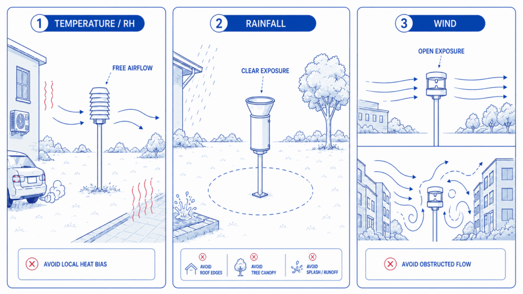
Exposure must match the question. Nearby heated walls, exhausts and large paved surfaces can distort local conditions, while direct solar loading on an inadequately shielded sensor can bias the measurement. Appropriate radiation shielding and free airflow are therefore part of the measurement design.
Rainfall
Short-duration rainfall can matter for drainage operations, public works and event review, while convective rainfall can vary substantially across a municipality. Gauges should therefore represent locations where precipitation information has an operational purpose.
The collection area should be protected from avoidable obstruction, splash and abnormal turbulence, and the surrounding exposure should be reviewed when vegetation or nearby structures change. Local rainfall observations can support event documentation and operational review, but rainfall measurements alone do not constitute a hydrological or flood-warning system.
Wind speed and direction
Wind measurements are especially sensitive to local exposure. Buildings, trees, walls and roof structures can change both speed and direction, so the correct location depends on whether the municipality needs a more open-area observation, conditions at a particular infrastructure site or local context for an environmental event.
A rooftop observation, a street-canyon point and an open-field observation answer different questions. A multi-parameter station is operationally efficient, but one physical exposure is not necessarily ideal for every parameter.
Pressure, solar radiation and other local environmental data
Atmospheric pressure and solar radiation can add context where the use case justifies them. Distinguish what must be measured directly, what can be imported from an authoritative source and what can be derived later. A long parameter catalogue is not a substitute for a clear operational question.
Siting and network design
Siting is parameter-specific
One good site does not automatically exist for every variable. Temperature, precipitation and wind respond differently to surfaces and obstacles, so a location useful for one parameter can be compromised for another.
Exposure and representativeness should be documented explicitly. The WMO/ISO Siting Classification provides a useful framework for doing this: an imperfect site is not automatically useless, but its limitations and representativeness need to be understood and recorded. The key is to use the observation at the scale the site can genuinely represent.
- Temperature / RH: consider radiant heat sources, direct solar loading, exhausts, shielding and airflow around the sensor.
- Rainfall: keep the collection area clear of avoidable obstructions and splash sources, and document surrounding obstacles.
- Wind: select exposure for the intended role; rooftop, street-canyon and open-field measurements should not be treated as equivalent.
- Site metadata: record coordinates, mounting height, photographs, nearby surfaces and obstacles, sensor configuration and the initial installation rationale.
Design the network around site classes, not equal spacing
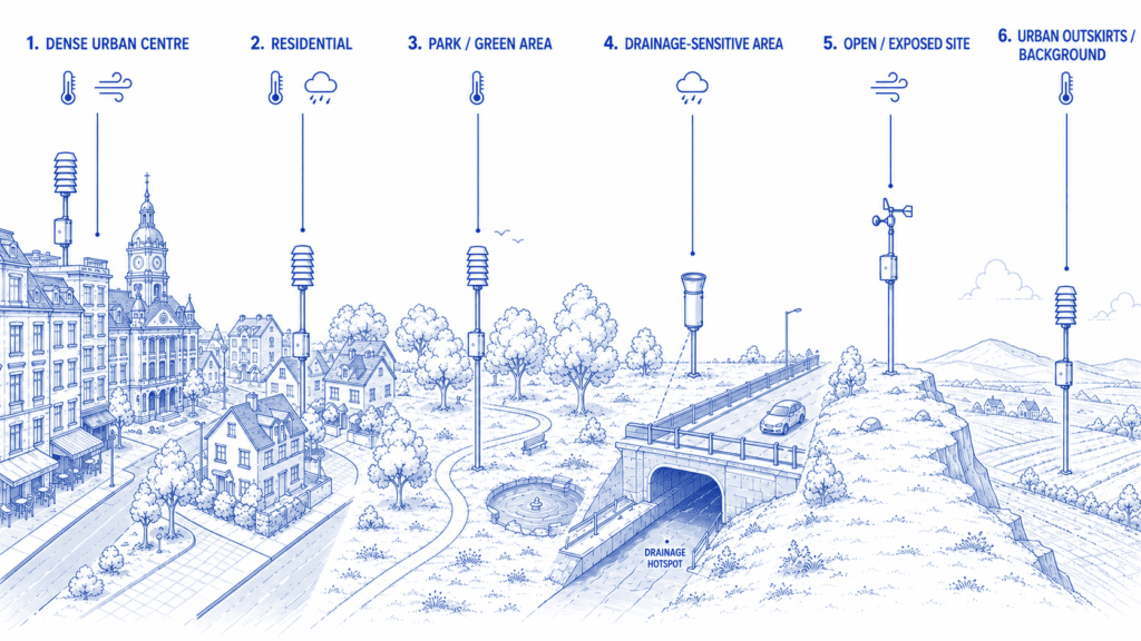
A regular grid can look systematic on a map while still missing the environments that matter. Municipal networks are usually stronger when they deliberately represent contrasting site classes and operational hotspots.
- Dense urban centre or highly built-up streets.
- Residential neighbourhoods.
- Parks and green areas.
- Open or exposed locations where less obstructed weather exposure is important.
- Drainage or flood-sensitive locations where local rainfall has an operational role.
- Urban outskirts or background locations for comparison with more modified urban environments.
Not every municipality needs all six classes. Each site should have a clear reason to exist, and the network should contain enough contrast to answer the intended questions. Power, communications, access and security matter to long-term operation, but convenience should not quietly become the scientific rationale for every site.
Use local data with regional and national observations
Before deploying new stations, inventory what already exists. National meteorological services, regional observing networks, hydrological systems, radar products, forecasts and official warning services may already provide authoritative information for part of the municipal requirement.
A local network should therefore add spatial resolution or operational relevance rather than duplicate existing infrastructure without a clear benefit. Municipal observations and wider public networks can be complementary layers: one provides local context, while the other continues to provide the authoritative regional or national framework.
A useful European example is the Municipality of Ravenna deployment under the Interreg Italy-Croatia STRENGTH project. The project combines three local weather stations measuring rainfall, wind, temperature and humidity with a broader municipal monitoring platform and planned integration of observations from other public networks. The useful principle is architectural: local stations and wider public observing systems can operate as complementary layers rather than competing systems. Where local weather observations are used to interpret air-quality measurements, see our guide to meteorological data in air-quality monitoring.
Operate the network as a decision system
Data quality is an operating process
Long-term usefulness depends on an operating process that makes data gaps and system changes visible rather than treating installation as the end of the project.
- Synchronize station clocks, use stable site/device identifiers and monitor data completeness.
- Define verification, calibration or comparison procedures appropriate to the instrument and purpose.
- Maintain and inspect sensors on a planned schedule, recording maintenance-affected periods.
- Log sensor replacements, hardware or firmware changes and station relocations so system changes are not mistaken for environmental change.
- Review sites periodically as vegetation, buildings, street furniture or infrastructure change around them.
Transparent metadata and quality control allow users to understand the limits of a practical site and use the data at the correct scale.
From weather measurements to municipal workflows
Continuous local observations become useful when the municipality has a defined review and response workflow rather than a dashboard with no agreed operational owner.
- Measure and transmit current conditions from the relevant sites.
- Add context by comparing neighbouring locations, recent history and authoritative wider-area information.
- Review whether a predefined municipal operational condition has occurred, keeping local thresholds distinct from official meteorological warnings.
- Investigate the observation in relation to the municipal function involved, such as drainage, public works, environmental management or site operations.
- Record the response and preserve the evidence needed for later reporting, evaluation or communication where appropriate.
Alerts should accelerate review, not replace professional judgement or be presented as official warnings. This workflow – measurement, contextual review, operational response and record – is more important than any single visualization.
How Aernode can fit into this architecture
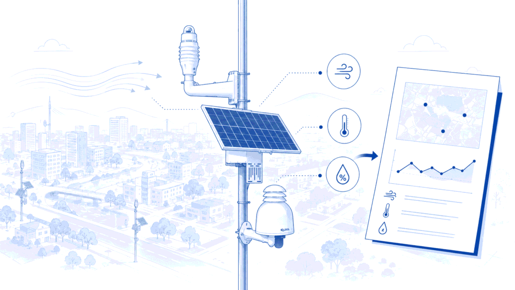
Aernode deployments can combine local air-temperature, relative-humidity and atmospheric-pressure measurements with meteorological accessories for wind, rainfall and solar radiation where required. Distributed measurements can be managed through Aernode Cloud, while Reporting Tools support visualization, review and reporting workflows, including compatible external datasets where useful to the project.
Practical checklist for a municipal weather monitoring network
- Define the municipal question before choosing station count.
- Inventory existing public observations, forecasts and warnings.
- Define the site classes or operational hotspots that need representation.
- Select parameters and exposure requirements site by site.
- Establish metadata, QA, maintenance and change-log procedures.
- Define data integration, review, alert and reporting workflows.
- Reassess the network when sites, infrastructure or municipal objectives change.
The strongest municipal weather network is not necessarily the one with the most stations. It is the one whose sites, measurements and data workflow are clearly connected to the questions the municipality needs to answer – and whose limitations are documented well enough for the observations to be interpreted at the right scale.
Technical References
1. World Meteorological Organization – Guide to Instruments and Methods of Observation (WMO-No. 8) – international technical guidance for meteorological observations, instruments, exposure and quality management.
2. World Meteorological Organization / ISO – Siting Classification for Surface Observing Stations on Land – international framework for describing siting, exposure and representativeness, with ISO 19289 context.
3. World Meteorological Organization – Integrated Urban Services for European Cities: the Stockholm Case – WMO overview of city-specific urban-service requirements and the integration of local observations with wider meteorological information.
4. Interreg Italy-Croatia STRENGTH – Municipality of Ravenna weather-monitoring example.