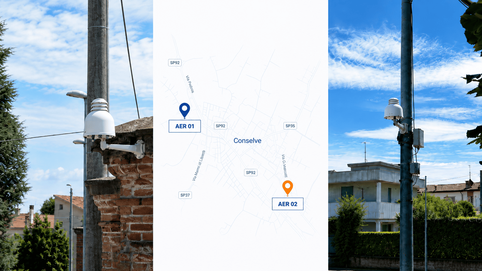
In Conselve, a municipality in the Province of Padua in northern Italy, odour-related concerns had emerged over time, but citizen reports were not yet collected through a consistent and structured process. Official ARPA monitoring campaigns had already provided institutional assessment of local air quality, while the municipality considered it useful to complement these activities with a continuous local monitoring layer. Two Aernode stations were therefore deployed, together with a dedicated reporting workflow designed to organise citizen reports in a consistent format. This combination allows reported events to be documented and reviewed alongside continuous ground-level measurements from two locations and the meteorological conditions observed at the same time.
Project context: an intermittent issue between official monitoring campaigns
Conselve had received recurring reports from residents about perceived odours in an area that also contains industrial activities. In response, ARPAV carried out several institutional air-quality campaigns. ARPAV’s 2023 Conselve monitoring campaign was requested after odour-nuisance reports and ran from 8 June to 26 July 2023.
Those institutional campaigns provide the official technical assessment context for the periods they cover. The municipality’s additional question concerned intermittent events occurring outside limited campaign windows. Such events may occur at other times, last for a limited period and depend on local meteorological conditions. Without a continuous record, a resident report can be difficult to compare with measurements taken at another time or place.
The project therefore focused on a narrower operational objective: create an additional local information layer that could preserve timing, location and context around reported episodes while keeping the evidence hierarchy clear.
Monitoring objective: use spatial comparison to investigate reported events
The network was designed to add spatial and meteorological context to reported odour events. The two monitoring locations were intentionally selected to represent different local conditions: one closer to the area where reports were more frequently concentrated, and a second in a more neutral position. Comparing the two time series, together with wind conditions, was intended to help the municipality understand whether environmental changes were localized, appeared at both locations or followed recurring patterns under specific meteorological conditions.
Two Aernode stations continuously monitored PM10, NO2, O3, NO, SO2 and H2S, alongside a VOC-related channel that used MOX sensing during the first approximately 18 months of the program. H2S and the VOC-related output were included as contextual indicators that could help characterize event timing and differences between the two locations when interpreted together with meteorology and citizen reports.
The hardware layer used the Aernode Air Quality Monitor, configured for the project’s selected particulate and gaseous parameters. The objective was to build a consistent multi-parameter record across both locations, allowing reported events to be examined through temporal trends, spatial comparison and wind conditions rather than as isolated measurements.
The two-point architecture: measurement, context and reporting
| Project layer | Role in Conselve |
|---|---|
| Two monitoring points | Continuous comparison of air-quality conditions at two municipal locations. |
| Measured parameters | PM10, NO2, O3, NO, SO2, H2S and a VOC-related MOX sensor output during the first approximately 18 months; PID-based VOC monitoring for the following project phase. |
| Meteorological context | Wind direction and wind speed reviewed alongside event windows. |
| Citizen reports | Structured record of date, time, approximate location, perceived intensity and description. |
| Data and reporting | Common historical record, trend review, periodic reporting and selected public-facing information. |
The data-management layer matters because event investigation depends on a common timeline. Measurements from both points were centralized through Aernode Cloud, while project reporting and visualization used Aernode Reporting Tools together with SmartMuni, Quanta’s supporting municipal information service. This separated the field measurement task from the practical work of reviewing trends, preparing periodic reports and making selected information accessible to stakeholders.
From a reported event to a structured review
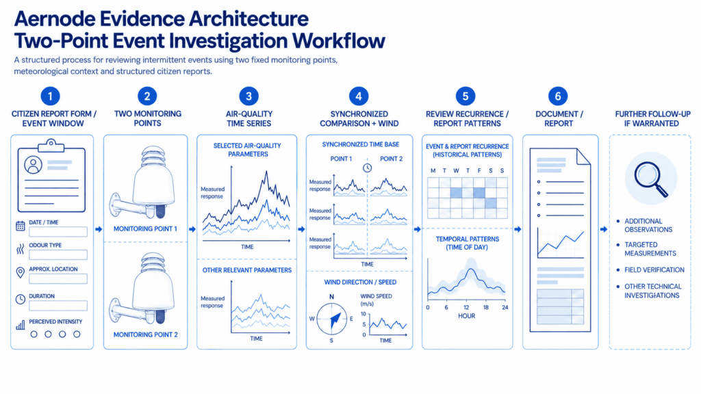
A continuous network becomes useful when the review method is as clear as the measurement method. In Conselve, the project created a repeatable sequence for examining an episode rather than treating each report as an isolated message.
- Record the event window. Use the citizen report to establish date, time, approximate location and perceived intensity.
- Retrieve both monitoring-point time series. Review the same period at both stations so the comparison is temporally aligned.
- Check relevant parameter changes. Look for changes in H2S, the VOC-related channel and the broader pollutant set without interpreting any single channel as a direct odour measurement.
- Add meteorological context. Review wind direction and speed for the event window to understand whether transport conditions could help explain differences between locations.
- Compare recurrence and reports. Check whether similar patterns appear at other times and whether multiple structured reports cluster around the same period.
- Document the interpretation and limits. Use the resulting evidence to support a report or technical discussion and decide whether further investigation by the municipality or competent authorities is warranted.
What changed for the municipality: from scattered reports to structured evidence
The main outcome is a structured evidence base in which citizen reports can be reviewed alongside continuous air-quality measurements and meteorological data. This allows recurring patterns to be compared more systematically and helps the municipality focus further investigation on the signals and conditions that recur most consistently.
Combining citizen reports with objective monitoring data
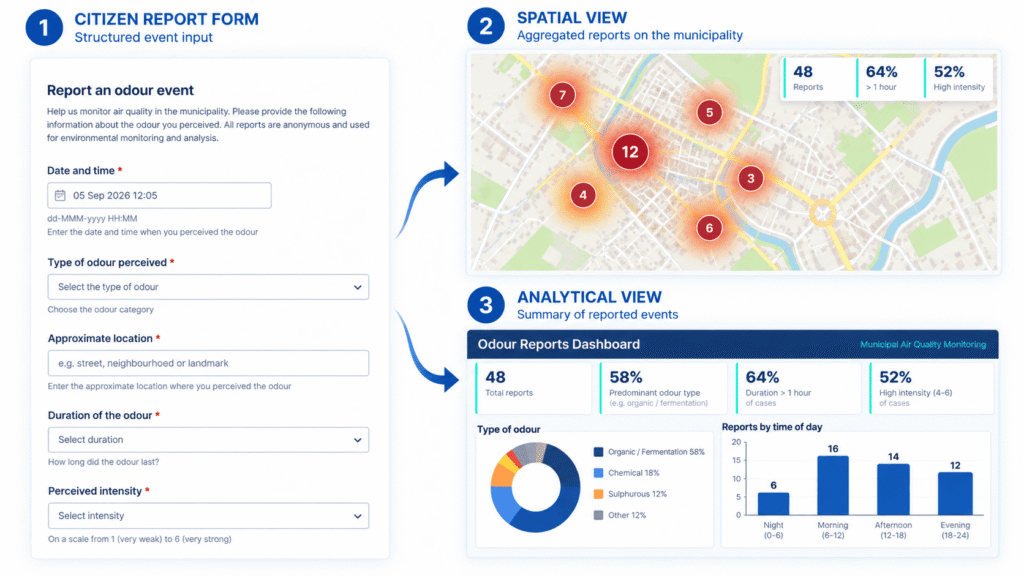
Before the continuous programme, residents could report a perceived odour and document when and where it was experienced, but measurement context might not exist for the same event window. The current workflow brings four evidence streams together: the citizen report, time-aligned measurements from two locations, meteorological conditions and historical recurrence. The citizen report remains subjective evidence; its value increases when it can be time-aligned with instrumental environmental measurements.
The network does not convert perceived odour into an instrument-certified quantity. It does something operationally different: it allows a subjective report to be associated with a documented environmental event window containing measured air-quality and meteorological context. The result is a repeatable event record that can be reviewed against earlier or later episodes rather than an isolated complaint.
The citizen-report form captures reports anonymously with date, time, approximate location, perceived intensity and description, while the monitoring portal provides current and historical network views. The Comune di Conselve publicly links residents to information from the installed monitoring stations, and the project’s municipal air-quality portal provides current and historical access alongside institutional information.
The data can narrow the investigation
Review of reported episodes during the initial monitoring phase showed a clearer qualitative association with VOC-related measurement patterns than with H2S patterns. During the initial monitoring phase, which lasted approximately 18 months, the VOC-related channel used MOX sensing. This remains an emerging finding from the project review: it does not identify the compound responsible for the perceived odour, establish causality, exclude H2S as potentially relevant under other conditions or identify a source.
The second phase of the project includes the integration of a PID-based VOC sensor to complement the information provided by the MOX-based observations. Using a different measurement principle and response profile provides an additional perspective on VOC-related events and can support more targeted investigation of recurring patterns. MOX and PID outputs are therefore interpreted according to their respective measurement characteristics rather than treated as directly equivalent. The additional PID information can help refine the investigation, but it does not provide chemical speciation or automatic source attribution.
Limitations: what two monitoring points can and cannot tell you
A two-point network adds comparison, but it is still a sparse representation of a municipality. The stations can show whether measured conditions differ across two selected locations and how those conditions evolve over time; they cannot reconstruct the full spatial field or identify an emission source on their own.
- Correlation is not source attribution. A change in concentration, a wind direction and a citizen report occurring in the same period can justify further investigation, but the combination does not by itself establish origin or responsibility.
- H2S and broad VOC sensor outputs are contextual indicators, not odour measurements. They can help characterize an event when relevant to the monitoring question, but perceived odour depends on compounds, mixtures, concentration, sensory response and context.
- The observed VOC-related association remains investigative evidence. It does not prove that VOCs caused the perceived odour or that a specific source was responsible. The finding applies to the monitored locations and event windows observed so far; the MOX and PID phases should be interpreted according to their respective measurement characteristics rather than as directly interchangeable continuations of the same VOC signal.
- Two points do not describe every neighbourhood. Siting determines what each station can represent; additional locations may be needed for broader spatial questions.
- Supplementary local data do not replace official assessment. Supplementary local monitoring can support investigation and local decision-making, while regulatory assessment and compliance decisions remain within the applicable competent-authority framework and prescribed methods. The recast EU framework is set out in Directive (EU) 2024/2881, subject to its implementation and transition timetable.
The same discipline applies to data quality. Distributed sensor networks can add temporal and spatial information, but their interpretation still depends on verification, quality control, uncertainty awareness and a clearly defined evidence role. European Commission JRC guidance provides additional technical context on sensor-network deployment and data quality.
Lessons for small municipal air-quality networks
The Conselve deployment suggests four practical principles for small municipal air-quality networks designed around intermittent local events:
- Start from the investigation question. Choose parameters, locations and reporting around the event that needs to be reviewed, not around the longest possible sensor list.
- Create a comparison, not just a single time series. Two locations can add useful spatial context when they are reviewed on the same timeline and their siting rationale is documented.
- Treat meteorology and structured reports as interpretation context. Wind direction, wind speed and timestamped citizen observations help frame differences and recurrence, but they do not prove origin.
- Plan the evidence workflow before deployment. Historical access, event review, periodic reporting and a clear route to deeper follow-up should be part of the monitoring design rather than an afterthought.
A small network is useful when the evidence chain is explicit
The main lesson from Conselve is not that two stations are enough for every municipality. It is that a small network can become operationally valuable when each point has a defined role and the measurements are connected to context, reports and a repeatable review process.
For distributed urban air-quality monitoring, that means using continuous local measurements to answer a specific municipal question without overstating what the data prove. The same evidence discipline is relevant where municipal concerns intersect with industrial-site monitoring: measurement can support investigation and follow-up, but source attribution and formal compliance require evidence appropriate to those decisions.
In Conselve, continuous monitoring has brought scattered citizen reports into a structured evidence base combining reported events with objective air-quality measurements and meteorological data. This makes recurring patterns easier to compare and helps focus further investigation where the evidence is strongest. The network does not identify the source or replace institutional assessment.
Technical References
1. ARPAV – Relazione tecnica della campagna di monitoraggio della qualità dell’aria, Comune di Conselve (2023). Official regional monitoring report and project context for the June-July 2023 campaign.
2. European Commission Joint Research Centre – Guidance on low-cost air quality sensor deployment for non-experts based on the AirSensEUR experience (JRC130628, 2022). Technical guidance on sensor-network design, verification, quality control, uncertainty and data use.
3. Directive (EU) 2024/2881 on ambient air quality and cleaner air for Europe. Recast EU ambient-air framework, cited to distinguish supplementary local monitoring from formal regulatory assessment and interpreted according to its implementation and transition timetable.